


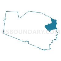
05-2 Nolensville Methodist Church Voting District, Williamson County, Tennessee
About
Outline

Summary
| Unique Area Identifier | 669999 |
| Name | 05-2 Nolensville Methodist Church Voting District |
| County | Williamson County |
| State | Tennessee |
| Area (square miles) | 32.70 |
| Land Area (square miles) | 32.68 |
| Water Area (square miles) | 0.02 |
| % of Land Area | 99.94 |
| % of Water Area | 0.06 |
| Latitude of the Internal Point | 35.91579600 |
| Longtitude of the Internal Point | -86.67660400 |
Maps


Graphs
Select a template below for downloading or customizing gragh for 05-2 Nolensville Methodist Church Voting District, Williamson County, Tennessee


Neighbors
Neighoring Voting District (by Name) Neighboring Voting District on the Map
- 04-2 Millview Church of Christ Voting District, Williamson County, TN
- 05-3 Triune Baptist Church Voting District, Williamson County, TN
- 05-4 Whispering Hills Church Voting District, Williamson County, TN
- 05-5 The Community Church Voting District, Williamson County, TN
- 08-1 Blackman United Methodist Church Voting District, Rutherford County, TN
- 09-2 Giles Creek Baptist Church Voting District, Rutherford County, TN
- 10-1 Cedar Grove Elementary Voting District, Rutherford County, TN
- 10-3 Rock Springs School III Voting District, Rutherford County, TN
- 31-3 Oasis Worship Centre Voting District, Davidson County, TN
Top 10 Neighboring County Subdivision (by Population) Neighboring County Subdivision on the Map
- District 31, Davidson County, TN (29,274)
- District 5, Williamson County, TN (21,796)
- District 4, Williamson County, TN (19,318)
- District 10, Rutherford County, TN (16,878)
- District 8, Rutherford County, TN (14,479)
- District 9, Rutherford County, TN (13,763)
Top 10 Neighboring Place (by Population) Neighboring Place on the Map
- Nashville-Davidson metropolitan government (balance), TN (601,222)
- Smyrna town, TN (39,974)
- La Vergne city, TN (32,588)
- Nolensville town, TN (5,861)
Top 10 Neighboring Unified School District (by Population) Neighboring Unified School District on the Map
- Nashville-Davidson County School District, TN (626,681)
- Rutherford County School District, TN (153,649)
- Williamson County School District, TN (147,489)
Top 10 Neighboring State Legislative District Lower Chamber (by Population) Neighboring State Legislative District Lower Chamber on the Map
- State House District 34, TN (101,480)
- State House District 63, TN (101,018)
- State House District 49, TN (81,804)
- State House District 56, TN (75,704)
- State House District 61, TN (74,549)
Top 10 Neighboring State Legislative District Upper Chamber (by Population) Neighboring State Legislative District Upper Chamber on the Map
- State Senate District 23, TN (254,672)
- State Senate District 16, TN (231,510)
- State Senate District 13, TN (227,448)
Top 10 Neighboring 111th Congressional District (by Population) Neighboring 111th Congressional District on the Map
- Congressional District 7, TN (792,605)
- Congressional District 6, TN (788,754)
- Congressional District 5, TN (707,420)
Top 10 Neighboring Census Tract (by Population) Neighboring Census Tract on the Map
- Census Tract 191.14, Davidson County, TN (9,429)
- Census Tract 408.05, Rutherford County, TN (8,050)
- Census Tract 501.01, Williamson County, TN (7,686)
- Census Tract 408.06, Rutherford County, TN (6,608)
- Census Tract 408.07, Rutherford County, TN (4,957)
- Census Tract 501.03, Williamson County, TN (4,011)
- Census Tract 501.02, Williamson County, TN (3,831)
Top 10 Neighboring 5-Digit ZIP Code Tabulation Area (by Population) Neighboring 5-Digit ZIP Code Tabulation Area on the Map
- 37013, TN (78,406)
- 37167, TN (49,322)
- 37027, TN (49,035)
- 37086, TN (31,513)
- 37067, TN (23,652)
- 37135, TN (9,681)
- 37014, TN (1,855)